Unified data backbone
4.6M+ wells, permits, production, logs, frac chemistry, geospatial and satellite layers harmonized into an analytics-ready lake with frequent refreshes covering nearly all of U.S. onshore + offshore output.
Solution • SaaS platform
ODIS is a live, AI-native decision workspace that maps and filters basin-scale wells, permits, and production in seconds — turning fragmented oilfield data into lease-ready acreage intelligence.
Capabilities
ODIS is built as a single AI-native stack: data backbone, analytics workspace, and model/agent layer—so you don’t have to bolt tools together.
4.6M+ wells, permits, production, logs, frac chemistry, geospatial and satellite layers harmonized into an analytics-ready lake with frequent refreshes covering nearly all of U.S. onshore + offshore output.
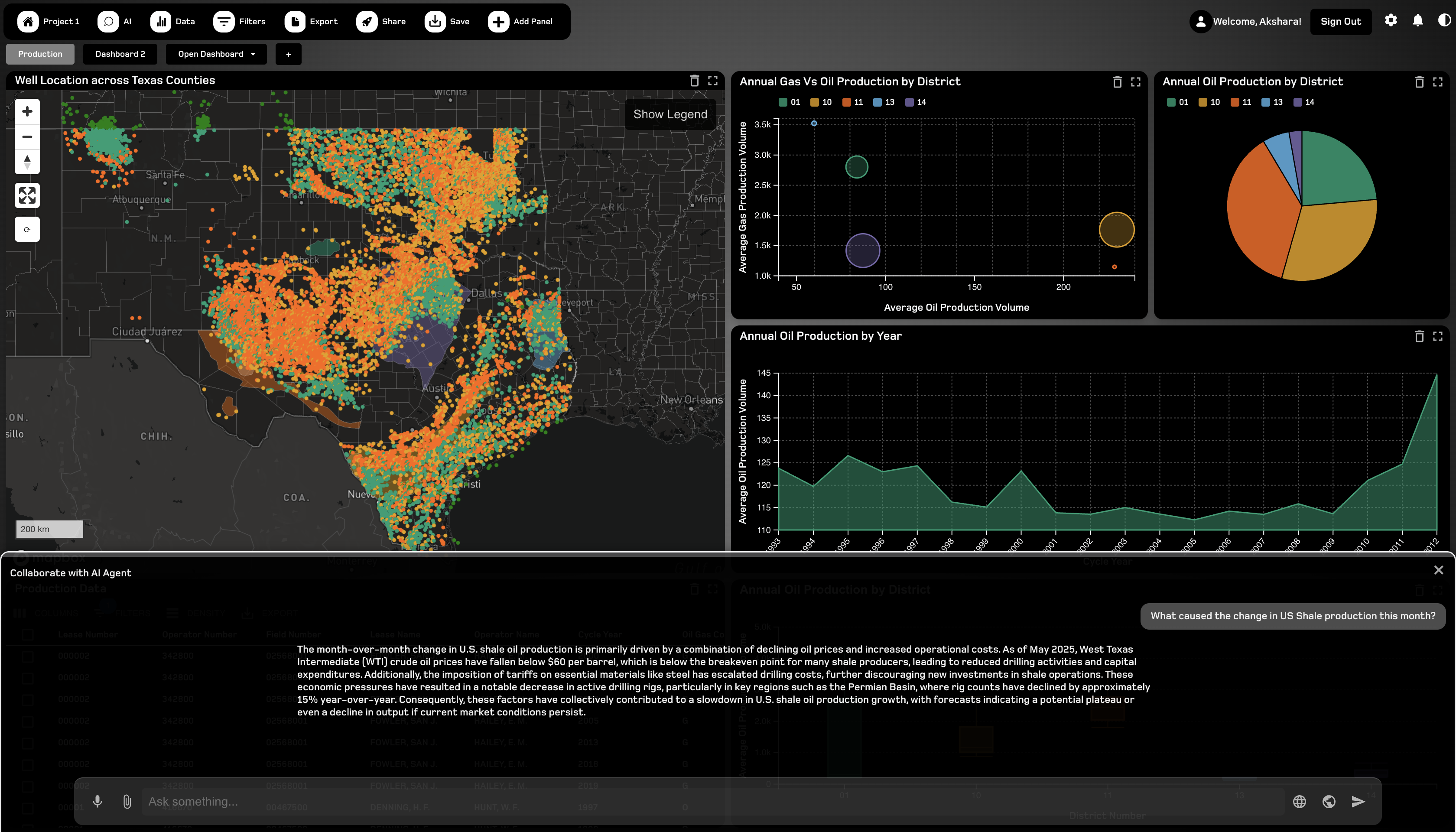
Interactive maps and dashboards, multi-panel projects, real-time whiteboards, in-app chat, file sharing and granular RBAC keep land team, engineering and finance on the same page.
Production forecaster, spacing/parent-child analysis, frac advisers and economics screeners plus an EnergyGPT-style copilot with NL-to-SQL and retrieval over ODIS + public filings.
Built-in decline and economics widgets, NPV/IRR roll-ups and heat maps to rank parcels and prioritize capital—without spreadsheet gymnastics.
Physics-informed ML flags pay zones and builds property cubes, while graph-based production surrogates power instant what-if scenarios. Powered by our Subsurface Simulator engine.
Stream data into Power BI, Tableau and Snowflake, launch GPU notebooks and a data-table IDE, and expose custom ML workflows via secure APIs.
AI-native core
ODIS bakes AI into the workflows that engineers, land teams and analysts actually use—forecasts, economics, subsurface scenarios and reporting—rather than bolting on a chatbot.
Ask natural-language questions over wells, permits, production and filings; get answers with links into dashboards, maps and underlying tables.
Turn questions into SQL, train models in GPU notebooks and push the results back into dashboards without leaving the browser.
Use physics-informed surrogates to try scenarios—spacing, frac recipes, price decks—and see uplift and risk metrics update in real time.
Live workspace
EnergyGPT · In-context answers
Ask questions directly from the AI panel and get answers anchored to the wells, permits and layers you’re already looking at—no context switching or copy-pasting.
Use cases
ODIS toolbox & roadmap
Modules package ODIS for different teams, from a single operator group to a cross-functional enterprise rollout.
GA: Feb 2026
Map every well, permit, and production record in seconds.
Q2 2026
User, seat, and analytics workspace for your teams.
Q2 2026
Real-time collaboration around projects and dashboards.
Q2 2026
Push ODIS data into the rest of your analytics stack.
Q3 2026
GPU-accelerated notebooks next to harmonized oilfield data.
Q3 2026
A low-code AI factory for subsurface and operations.
Q4 2026
Live economics wired to production and price decks.
Q1 2027
Production-grade AI for frac design and reservoir uplift.
Pricing · ODIS Explore
Live now
billed monthly per seat
Map-first analytics for wells, permits and production, with projects, filters and dashboards for your team, with the same AI-native core as the full platform.
.edu domains receive an additional 50% off their Explore subscription.Discounts apply to ODIS Explore seats only. Volume and enterprise pricing are available on request.
Insights
Deep dives into the data, methods, and results behind this product.
Why We Fine-Tuned LLaMA 3.1 on Two Decades of Energy Literature
General-purpose LLMs fall short in the energy sector — hallucinated references, confused units, vague thermodynamics. We built EnergyGPT by fine-tuning LLaMA 3.1-8B on 2.17 billion tokens of curated energy text, and the results show meaningful gains in technical depth, coherence, and domain relevance.
How We Integrated 1.1M+ Wells from the Texas Railroad Commission
A deep dive into how TerraNavitas built automated ETL pipelines to ingest, harmonize, and serve 1.1M+ wellbores across 14 RRC dataset categories — from raw EBCDIC files to a cloud-native, queryable database powering interactive dashboards.
Also from TerraNavitas
Bring a county, basin or prospect of interest and we’ll walk through how ODIS unifies data, analytics and AI to sharpen your next capital decision.